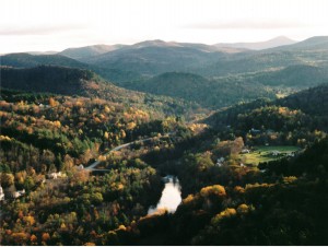
EDIT: CAPTION: The White River is the heart of the watershed’s working landscape.
Land Use
A combination of forest, agricultural fields, farms, and historic towns make the watershed one of the most picturesque in New England. The landscape in the basin is hilly and predominantly forested with the developed and agricultural lands situated in the valleys. Forested land covers 84{db44c3d5e5b2521111bb9179cb40e40c4d2777ab57a0c9e12ea819349259de2f} of the basin and agricultural land occupies about 7{db44c3d5e5b2521111bb9179cb40e40c4d2777ab57a0c9e12ea819349259de2f}. Developed land, including residential, commercial, industrial, transportation, and utilities, covers about 5{db44c3d5e5b2521111bb9179cb40e40c4d2777ab57a0c9e12ea819349259de2f} of the basin. The remaining 4{db44c3d5e5b2521111bb9179cb40e40c4d2777ab57a0c9e12ea819349259de2f} of the landscape is water. The predominance of forest cover and the small amount of developed land are the primary reasons for the good water quality in most of the basin.
Agriculture is an important component of the environmental, cultural and economic make-up of the White River watershed. Land devoted to agriculture makes up 7{db44c3d5e5b2521111bb9179cb40e40c4d2777ab57a0c9e12ea819349259de2f} of the watershed’s entirety covering an area of over 34,000 acres. Agricultural land is used for raising everything from horses and dairy cows, to pumpkins, vegetables, hay and cut flowers. Of all the land in the watershed owned by farmers, less than half is in crop production. Woodlands expand the diversity of production from farm owned land to include forest products, maple syrup, and firewood. The current 356 farms in the basin can be estimated to be producing goods worth $29 million in market value (as of 2002).
Forestland covers 84{db44c3d5e5b2521111bb9179cb40e40c4d2777ab57a0c9e12ea819349259de2f} of the White River watershed. Uses of the forest include, but are not limited to, recreation, wildlife habitat and timber harvesting. Outside of areas in the Green Mountain National Forest or in state ownership, forestland is owned for the most part by individuals with diverse goals allowing for a variation in management in terms of uses, strategies, time-frames and intensity.
Over the last 200 years, land has been developed adjacent to rivers to take advantage of the benefits the river provides such as travel routes, fertile flood plain soils, hydropower and water supply. In addition, due to the hilly nature of the White River watershed, the desirable land for development is within the flatter valley floors where the river corridors are situated. The roads, houses and parking lots that make up the developed areas cover approximately 5{db44c3d5e5b2521111bb9179cb40e40c4d2777ab57a0c9e12ea819349259de2f} of the watershed. The developed area has generally led to reduced water quality when building resulted in the removal of vegetation along the stream corridor, the filling of flood plains and the disposal of untreated runoff from these areas into the river.
Land Use
EDIT: CAPTION: The White River is the heart of the watershed’s working landscape.
Land Use
A combination of forest, agricultural fields, farms, and historic towns make the watershed one of the most picturesque in New England. The landscape in the basin is hilly and predominantly forested with the developed and agricultural lands situated in the valleys. Forested land covers 84{db44c3d5e5b2521111bb9179cb40e40c4d2777ab57a0c9e12ea819349259de2f} of the basin and agricultural land occupies about 7{db44c3d5e5b2521111bb9179cb40e40c4d2777ab57a0c9e12ea819349259de2f}. Developed land, including residential, commercial, industrial, transportation, and utilities, covers about 5{db44c3d5e5b2521111bb9179cb40e40c4d2777ab57a0c9e12ea819349259de2f} of the basin. The remaining 4{db44c3d5e5b2521111bb9179cb40e40c4d2777ab57a0c9e12ea819349259de2f} of the landscape is water. The predominance of forest cover and the small amount of developed land are the primary reasons for the good water quality in most of the basin.
Agriculture is an important component of the environmental, cultural and economic make-up of the White River watershed. Land devoted to agriculture makes up 7{db44c3d5e5b2521111bb9179cb40e40c4d2777ab57a0c9e12ea819349259de2f} of the watershed’s entirety covering an area of over 34,000 acres. Agricultural land is used for raising everything from horses and dairy cows, to pumpkins, vegetables, hay and cut flowers. Of all the land in the watershed owned by farmers, less than half is in crop production. Woodlands expand the diversity of production from farm owned land to include forest products, maple syrup, and firewood. The current 356 farms in the basin can be estimated to be producing goods worth $29 million in market value (as of 2002).
Forestland covers 84{db44c3d5e5b2521111bb9179cb40e40c4d2777ab57a0c9e12ea819349259de2f} of the White River watershed. Uses of the forest include, but are not limited to, recreation, wildlife habitat and timber harvesting. Outside of areas in the Green Mountain National Forest or in state ownership, forestland is owned for the most part by individuals with diverse goals allowing for a variation in management in terms of uses, strategies, time-frames and intensity.
Over the last 200 years, land has been developed adjacent to rivers to take advantage of the benefits the river provides such as travel routes, fertile flood plain soils, hydropower and water supply. In addition, due to the hilly nature of the White River watershed, the desirable land for development is within the flatter valley floors where the river corridors are situated. The roads, houses and parking lots that make up the developed areas cover approximately 5{db44c3d5e5b2521111bb9179cb40e40c4d2777ab57a0c9e12ea819349259de2f} of the watershed. The developed area has generally led to reduced water quality when building resulted in the removal of vegetation along the stream corridor, the filling of flood plains and the disposal of untreated runoff from these areas into the river.